Showing 4 items matching central land office
-
 Glen Eira Historical Society
Letter - Hopetoun, Hopetoun Street, 2, Elsternwick
... Central Land Office... of the Central Land Office to Florence M Cordner, dated 29/04/1904... of the Central Land Office to Florence M Cordner, dated 29/04/1904 ...A copy of a one page typed letter, from C J and T Ham of the Central Land Office to Florence M Cordner, dated 29/04/1904, providing a valuation of her property located at the corner of Glen Huntly Road and Hopetoun Street, Elsternwick. The valuation provides a description of the land, house improvements and architectural features and outlines possibilities for land subdivision. Noted on the document in pencil is 'From collection of Brighton Historical Society'.cordner florence mrs, glen huntly road, glenhuntly road, elsternwick, hopetoun street, moynsha, melrose, campbell a l, towers, verandahs, brick, stables, ham c j, ham t, c j & t ham, central land office, mansions -
 University of Melbourne, Burnley Campus Archives
Plan, Plan of Richmond Park, 1886-1948
(1) Black and white photographed copy of an original coloured plan. Plan of Richmond Park with Horticultural Society Gardens marked in. Includes additional land which became the Field Station. Stamp, "Neg. 18375 Department of Lands and Survey Photographed at the Central Plan Office 1/1 Plate 7.12.48". Original plan dated 19.11.86 showing land, "Permanently Preserved for the Gardens." (2) Also 2 photocopies, 1 reduced - possibly used in a publicationgardens, richmond, horticultural society of victoria -
 Kew Historical Society Inc
Photograph - Victorian Double-fronted Brock Villa, Cotham Road, c. 1919
The Kew Historical Society's map collection includes a substantial number of real estate subdivision plans, mainly of Kew but also of surrounding suburbs in Melbourne. Most of the subdivision plans date from the 1920s and 1930s when the districts old homes and local farmland were being split up to accommodate residential growth in the postwar period. These early plans were assembled by a local firm, Jas R Mather & McMillan, which had an office in Cotham Road. Many of the plans, and sometimes photos, were annotated by the agents.Subdivision plans are historically important documents used as evidence for the growth of suburbs in Australia. They frequently provide information about when the land was sold as well as evidence relating to surveyors and real estate and financial agents. The numerous subdivision plans in the Kew Historical Society's collection represent working documents, ranging from the initial sketches made in planning a subdivision to printed plans on which auctioneers or agents listed the prices for which individual lots were sold. In a number of cases, the reverse of a subdivision plan in the collection includes a photograph of a house that was also for sale by the agent. These photographs provide significant heritage information relating house design and decoration, fencing and household gardens.The photograph may also be aesthetically significant depending o the importance of the photographic atelier.Real estate photographs of a classic double-fronted late Victorian brick villa. It central location in Cotham Road, Kew enabled the selling agent to note its proximity to the tram. With seven rooms, all ‘modern conveniences’, and land of 66×167, the house was to be sold for £1100. The villa has a number of interesting features including a pattern within the slate roof as well as the use of polychrome brickwork under the eaves and on the façade. The intricacy of the cast iron lace is emphasised by the line of projecting wooden blocks above it. The picket gate is painted a different colour to the pickets of the fence. The house has a name (illegible) that is attached to the inset cast iron lace of the central projecting gable in the veranda. Stamped on mount: "Kew. Central. Close tram. / Comfortable Brick Villa. / Containing 7 rooms / Modern conveniences: / Land 66 x 167. Sold 1100 pounds:"houses - kew, victorian villas, real estate photographs, cotham road - kew -
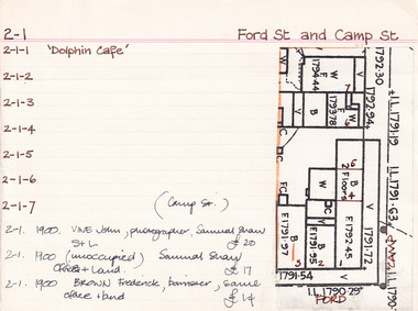 The Beechworth Burke Museum Research Collection
Card (Series) - Index Card, George Tibbits, Cnr Ford and Camp Streets, Beechworth, 1976
George Tibbits, University of Melbourne. Faculty of Architecture, Building and Town & Regional PlanningIndex system that support the research for Beechworth : historical reconstruction / [by] George Tibbits ... [et al]Arranged by street names of BeechworthEach index card includes: street name and number of property, image of property, allotment and section number, property owners and dates of ownership, description of the property according to rate records, property floor plan with dimensions.beechworth, george tibbitsbeechworth, george tibbits